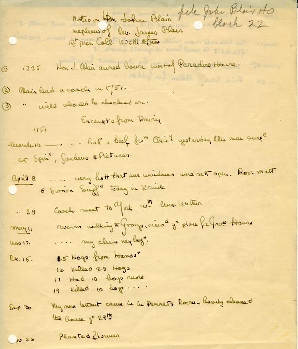
John Blair House Historical Report, Block 22 Building 5 Lot 36Originally entitled: "The Blair House Block 22, Lot #36 (on Annie Galt Map)"
Colonial Williamsburg Library Research Report Series - 1495
Colonial Williamsburg Foundation Library
Williamsburg, Virginia
1990
THEJohn BLAIR HOUSE
Block 22, Lot #36 [on Annie Galt Map]Bldg. 5
Obsolete Report
McWilliams, 1943
Although it can be established that John Blair, Jr. lived in the house now standing on this lot, it is not so certain that these are the lots where John Blair, Sr. lived. The question hinges on whether the son accepted as his, residence the lots and houses which his father left him by will. In his will made Oct. 5, 1771, John Blair, Sr. left his son of the same name "all those lots and houses where I now live, also the four lots whereon my storehouse stands with all their appurtenances to him and his heirs forever". (York County Records, Book 22, Wills, Inventories, p. 44.)
Certain facts must be considered as related to the question of whether John Blair, Sr. lived on Block #22. John Blair, Sr. had a garden on a lot adjoining Market Square as early as 1739. Deeds to a lot adjoining John Blair's Market Square lot contain references to his garden as a boundary until 1762, when the phrase "the lot of the Hon. John Blair, Esq.," is used in the deeds (See the report on Chowning's Tavern, Block 18 ? lot 147?). The Presence of John Blair's garden implies his residence on the Market Square lot. According to a document dated June 2, 1746, Blair's lease on this property was to expire at the end of 21 years, i.e. in 1767 (See Mss. document in possession of Research Department, Colonial Williamsburg). Secondly, John Blair, Jr. was about forty years did when his father died in 1771. He was born in 1731 according to a secondary source (William and Mary Quarterly, First Series, Vol. 7, pp. 133-134), was elected mayor in 1751 (Virginia Gazette, Hunter, Dec. 5), and at his father's death was himself the head of a family. (York Co. Records, Book 22, Wills, Inventories, p. 44.) In spite of this fact, it is apparent that when the younger Blair 2 who was executor of his father's estate advertised his father's personal estate for sale at the latter's dwelling house in Williamsburg, in 1773, nothing was said about the sale of John Blair, Sr.'s house. (Virginia Gazette, Purdie & Dixon, Sept. 2, 1773.)
The first reference to John Blair, Jr.'s lot is found in the advertisement of property on Duke of Gloucester Street. In 1773, an announcement of the contemplated sale of property on Main Street mentions John Blair as having lots on that street opposite the property advertised. The announcement reads:
To be SOLD by publick Auction … THE HOUSES and LOT, on the main Street in the City of Williamsburg, where the late Mrs. Catherine Blaikley, deceased, lived, adjoining the Lots of Mr. Charles Taliaferro, and opposite those of John Blair, Esquire …
(Virginia Gazette, Purdie & Dixon, January 7, 1773)
The purchaser of the advertised lot in the above announcement was Severinus Durfey1, who occasionally entered notices in the Virginia Gazette during the next six years. Durfey's first announcement shows that he was located in the Blaikley house, opposite John Blair's:
SERVERINUS DURFEY, TAILOR
WILLIAMSBURG,BEGS Leave to inform his Friends and Customers, and the Publick in general, that he has removed to the House lately occupied by firs. Catherine Blaikley, nearly opposite to John Blair, Esquire's, and next Door to Mr. Charles Taliaferro's …
(Virginia Gazette, Purdie & Dixon, April 8, 1773)
In 1779, Durfey advertised that he had "his store in the upper end of this city, opposite the Hon. John Blair's, Esq; …" 3 [Ibid. Clarkson & Davis, Aug. 28, 1779.]
References to houses and lots, apparently on Prince George Street indicate that Blair continued to live in his house near the church in the late eighteenth century. James Innes announced the sale of the houses and lot on which he lived on "the back street near the church adjoining the Hon. John Blair…" (Virginia Gazette, Clarkson & Davis, July 3, 1779.) Blair's lots were one of the boundaries, mentioned by Innes's purchaser, Joseph Thompson, in the deed which transferred the Innes property to James Wilson, gardener of the College of William and Mary c. Feb. — June 1780. Thompson described his property as
"All that lot of ground and houses situate lying and being in the city of Williamsburg and bounded on the South and West by the lots of Hon. John Blair, Esq., whereon the said Joseph now lives and which were purchased by the said Joseph of Col. James Innes".(York Co. Records, Book VI, Deeds, p. 101.)
The Frenchman's Map of the 1780's shows the main house as a rectangular house in the centre of this block. West of the main house and near it is a small square house. East of the main house and at the extreme eastern end of the block and on the Duke of Gloucester Street is a long narrow rectangular building.
 Not Drawn to Exact Scale.
From 1789 — 1792, John Blair was entered on the Ledger of Humphrey Harwood as a debtor for repair work done. One of the accounts refers to a marble mantelpiece; also one very large fireplace:
Humphrey Harwood Ledger C
(Page 3)
| THE HON'BLE, JOHN BLAIR ESQR -- | Dr | Cr | |
| 1789 rd | |||
| June 23 | £ 8 5 2 | ||
| To 2 bushels of whitewash 3/ mending plaistering in 7 rooms & 4 passages 8/ | 11 | ||
| To plaistering 3 fireplaces 2/ | 2 | ||
| To whitewashing 7 Rooms and 4 passages at 3/9 | 2 1 3 | ||
| To Do 2 closets 2/6 — and mending a stove do 2/ | 4 6 | ||
| To taking down and mending 85 yds of plaistering | |||
| at 3d | 1 1 3 | ||
| To labr 5/ & Hair 3/9 | - 8 9 | ||
| 1790 | |||
| March 16 | To building up the Jambs of the library Chimney, setting up the Copper, mending the backs of the chimnies — mending the underpinning of the outhouses and the Brick work of the well | 2 - - | |
| Augt 12 | To underpinning a Porch 5/ | 5 | |
| £16 4 5 | |||
| (Sea Postea 44.) | |||
| Humphrey Harwood Ledger C | |||
| (Page 44) | |||
| 1790 nd | To amt brought from folo 3 ante | £ 16 4 5 | |
| Septr 22 | To 25 bushels of lime at 9 | 18 9 | |
| To setting up 2 grates — (one very large)--taking down the marble mantlepeice — and taking up the Hearth — and relaying them 18/S. | 18 | ||
| To laying 4 Hearths & mending 2 do, 11/3 | 11 3 | ||
| To plaisering 32 ½ yards … at 2d | 5 4 | ||
| To whitewashing 7 Rooms at 3/ | 1 1 | ||
| To | 8 | ||
| To -- do ......2 Closets & porch 3/ | 3 | ||
| To 4 ½ bushels of whitewash at 1/3 | 5 7 ½ | ||
| To mending the Tops of the Chimnies 2/ | 2 | ||
| By the Rent of the Brickyard — for the years 1786- | |||
| 87-88-89-90 at 40/ | £10 | ||
| Bal. due 10.8.5 | |||
| 1791 th | |||
| Jan. 27 | By Cash in part by Mr Dawson | £ 6 10 8 | |
| April 3 | To Peck of whitewash 3d 3/4 whitewashg Room 3/ | 3 3 ¾ | |
| June 6 | To 1 ½ bush: whitewash at 1/3 | 1 10 ½ | |
| To whitewashing 3 Rooms & 2 passages at 3/6 | 17 6 | ||
| To do the Porch 1/3 | 1 3 | ||
| Augt 16 | To lime and altering the grate 2/6 | 2 6 | |
| 1792 | |||
| March 25 | To whitewash & whitewashing Room & passage | 8 1 ½ | |
| April 2 | To do & do a passage | 3 9 | |
| June 28 | To cash in full | £6 5 0 ¼ | |
| £22 15 8 ¼ | £22 15 8 ¼ |
Ownership of the lots in Block 22 is indicated on the 4 extant plats of the city of Williamsburg. (The Bucktrout Man of 1803 is almost so faded as to be almost illegible. It should be noted that all of these maps or plats seem to have a common course. Three show the name "Andrews" in the centre of the lot about where the present house stood. In the Annie Galt man this lot is numbered #36; on the Unknown Draftsman Map the name "Andrews" is in the lot. Since Robert Andrews married Mary Blair, the daughter of John Blair, Jr. in 1795 (Virginia Gazette and Weekly Advertiser, Thomas Nicolson, Ed. March 28), it is probable that the name "Andrews" was inserted in the map after that date.
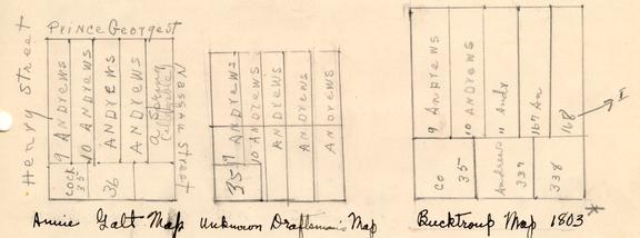 Figure 2
Duke of Gloucester on Main Street
Many of the numbers on this map, as well as some of the names[?], look as if they had been written over, so as to make the lot numbers and names bolder and therefore more legible. — Mary E. McWilliams
An insurance policy of 1809 shows that Robert Andrews' widow lived in the house under discussion. The house had been insured at an earlier date by Robert Andrews. The houses were described as "note named by Robert Andrews' widow and children and are now, occupied by Mary Andrews".
 6
The buildings were "situated on the main street — having on the north a street which divides Prentis' lots — on the West Cockes lots — on the south the main street and on the east an open space which divides the church — " The dwelling house was appraised at $3000, the office at $400. (Policy No. 989, p. 7 in a book of photostatic copies of insurance policies taken out with the Mutual Assurance Society of Virginia.) This policy shows that a one-story wooden dwelling house 64 feet by 28 feet, a detached kitchen 18 feet back of the dwelling, a laundry and a one-story wooden office 24 feet x 16 feet stood on the lot in 1809.
6
The buildings were "situated on the main street — having on the north a street which divides Prentis' lots — on the West Cockes lots — on the south the main street and on the east an open space which divides the church — " The dwelling house was appraised at $3000, the office at $400. (Policy No. 989, p. 7 in a book of photostatic copies of insurance policies taken out with the Mutual Assurance Society of Virginia.) This policy shows that a one-story wooden dwelling house 64 feet by 28 feet, a detached kitchen 18 feet back of the dwelling, a laundry and a one-story wooden office 24 feet x 16 feet stood on the lot in 1809.
The Williamsburg Lot Transfers (originals are in the Virginia State Archives,Richmond, Va.) how that John Blair [Jr.] was in possession of ten lots from 1782 through 1796. The Williamsburg Tax Records (originals in Virginia State Archives) on the other hand show that John Blair was taxed for 10 lots in 1785 and 1791, and for 1 lot in 1797. However the one lot had the same valuation in 1797 as the 10 lots had had in 1791. From 1799 through 1804, Robert Andrews who had married John Blair's daughter, Mary, was taxed for 6 lots.
Robert Andrews1 died before Feb. 27, 1804. (Folder 124, Southall Papers, College of William and Mary.) By his will, his property was left to his wife and his five children. (Ibid.) from 1806 through 1820, "Robert Andrews Estate" was taxed for 7 lots.
In 1820, a change was made in the method of keeping the Williamsburg tax records. More than one contiguous lot appears to be enumerated as one; also the value of the buildings on the lots, and the total value including lots and buildings was estimated. Thus the important facts regarding the lots of the "Robert Andrews Estate" appear on the tax records 7 from 1820 through 1843 as follows: [In part]
| Owner | Tenure | No. of lots | Value ofbuildings in the lots | Value of buildings and lots |
|---|---|---|---|---|
| Andrews, Robert Est. | in fee | 1 | ------- | $ 50 |
| in fee | 1 | $1200 | $1500 |
From a letter of March 20, 1833, it is apparent that Dickie Galt of Williamsburg rented the house for his sister, Mrs. Saunders (John Andrews to George Southall, Southall Papers, Folder 12/ College of William and Mary). Apparently, as a result of a suit against Galt to recover rent, the property came into possession perhaps as trustee of George Taylor, husband of Robert Andrews' granddaughter, Catherine Randolph. In the tax transfers for 1841, George Taylor is shown as having come into possession of "1 lot via John Coke Comm. formerly Est. of Robert Andrews".
In the year 1847, John T. James appears on the tax records us the owner of a lot, the buildings on which were worth $1200. This property James acquired "From Geo. Taylor in 1846". It had been "formerly charged to Ro: Andrews estate".
In 1856, Robert Saunders, agent, offered through the column of the Williamsburg Weekly Gazette (Editor, J. Harvey Ewing, Aug. 14) two dwelling houses owned by John T. James. Saunders described one of the houses as new;1 both, he said were large with all the appurtenances necessary for the comfort of a large family. Both houses were on Main Street.
It cannot be said that one of these houses was the Blair-Andrews house, but this property was evidently sold at some time around or before the Civil War to Garrett and Small; the deed was recorded in the Williamsburg Hustings Court, the records of which were destroyed during the Civil 8 War. This loss made it necessary for George W. Garrett to institute a suit against John T. James and his wife. As a result of the suit, the following decree eras issued:
"Upon the petition of George W. Garrett to set up and re-establish a deed of bargain and sale which had been lost ordestroyed, it appearing to the court from the report of the Special Commissioner William R. C. Douglas and the evidence returned therewith that in the year _________, John T. James and wife made and executed a deed of bargain and sale to George W. Garrett and James E. Small, a certain lot and the house thereon known as the Andrews property and situate on the north side of Main Street and that said deed was duly recorded in the Clerk's office of the Hustings Court of this City and has been lost or destroyed, it is therefore ordered that the said deed bargain and sale as hereinbefore described be set up and re-established…" (This deed, obtained from the James City Court House is in the Abstract of Titles 1,013 Block 22, No. 5 in possession of Williamsburg Restoration.)
The Williamsburg Tax Records for 1854 and 1561 show that George W. Garrett of James City County had one lot, the value of which was $11,.00. The value of $1050. was attributable to the houses on the lot.
Mr. John S. Charles who lived in Williamsburg at the time of the Civil War said that the "Blair house" then presented very much the same appearance as it does now. For many years before, during and after the Civil War, it was used different persons, and for various purposes. Just preceding the War it was used as a dwelling by two families. The uptown end was occupied by a baker and his family. He conducted a bake shoe in the basement, which had steps leading up to-the street. In 1861 it was occupied by a man who conducted a harness shop in the uptown end. (Recollections of Williamsburg, typed mss. p. 18.)
During the War the Federal Army finding that there was a brick bake oven on this property, took charge of it and greatly enlarged the capacity of the oven which extended from the basement out into the back yard. Its oval top, covered with earth, was enjoyed by the children of the community 9 as a place to romp on. This shop was operated by Federal soldiers, bakers, who daily made up and baked wagon loads of bread which was hauled in army wagons each morning and evening down to Fort Magruder for the troops camped there. In the yard of the old Blair house stood an old wooden kitchen of ample proporations was not removed until after the war. (Recollections, p. 18.)
Mrs. Victoria Lee is also recalled the "Blair house" as presenting c. 1860 its present apearance. She remembered that it was occupied at the time of the Civil War by two families. (Ibid., p. 82.)
In summary: Although John Blair, Sr. left his dwelling house and lots to his son of the same name, and John Blair, Jr. appears to have lived in this house, there is no other evidence that the elder Blair lived in this house. From the time of the ownership of the Rev. Robert Andrews at the turn of the century on, it is possible to trace a succession of owners, the number of which is few due to the fact that it remained as the Andrews Estate until the middle of the 19th century. The Frenchman's Map of 1782 [?] showsthe number of buildigns on the lot, their approximate floor dimensions, and their locations relative to each other. An insurance policy of 1809 gives the floor dimensions of the house, a store and a kitchen, their distances from each other and the number of stories in each building. All the buildings on this lot were wooden. Citizens who remember in the twentieth century how buildings in Williamsburg looked at the time of the Civil War decalre that the outward appearace of this dwelling has remained unchanged for over half a century.
The only proof aside from an archaeological one of a building east of the "Blair" house in the eighteenth century is the long, narrow rectangular building on the Frenchman's map. According to the insurance policy taken out on the Andrews' property in 1809, there were no houses between the dwelling and Bruton Parish Curch. The policy refers to "an open space" between Andrews' buildings and the church. Mr. Charles whose 10 recollections constitute one of the sources for the 19th century appearance of Williamsburg says that "The next house to the east of the Blair house sand standing in the 1920's3 eras built not many years previous to the [Civil] War (but within the memory of the writer), by Mr. John James… " (Recollections, p. 18). This statement does not preclude the existence of other buildings on this lot after 1809.
Hunter D. Farish, Director or
Department of Research and Record
Report prepared by
Mary E. McWilliams
December, 1943
Footnotes